NASA continues tracking Tropical Cyclone Harold's excessive rainfall

powerful Tropical Cyclone Harold from the Solomon Islands to the island of Tonga in the South Pacific. Satellite data was used to calculate the rainfall generated as Harold moved through the Southern Pacific Ocean. NASA also provided infrared imagery on Harold.
powerful Tropical Cyclone Harold from the Solomon Islands to the island of Tonga in the South Pacific. Satellite data was used to calculate the rainfall generated as Harold moved through the Southern Pacific Ocean. NASA also provided infrared imagery on Harold.
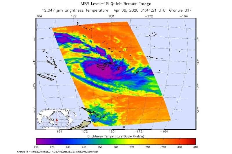
On April 8 at 0141 UTC (April 7 at 9:41 p.m. EDT) NASA's Aqua satellite analyzed the storm using the Atmospheric Infrared Sounder or AIRS instrument when it was major hurricane. AIRS found coldest cloud top temperatures as cold as or colder than minus 80 degrees Fahrenheit (minus 62.2 Celsius). NASA research has shown that cloud top temperatures that cold indicate strong storms that have the capability to create heavy rain.
Visualizing Harold's Heavy Rainfall
Harold's path of heavy rain from April 2 to 9 was calculated and mapped in an animation created at NASA's Goddard Space Flight Center in Greenbelt, Maryland.
The animation shows the heavy precipitation associated with Tropical Cyclone Harold as it progresses from the Solomon Islands on April 2, 2020 to its movement beyond the island of Tonga on April 8. Harold's core region produced precipitation rates in excess of 30 millimeters per hour, which is equivalent to a 7-inch-deep rain accumulation if the core region were to remain over a given location for 6 hours. The precipitation estimates in this animation come from the IMERG multi-satellite algorithm developed by NASA and run in near real-time.
The precipitation estimates in this animation come from the IMERG multi-satellite algorithm developed by NASA and run in near real-time.
What is NASA's IMERG?
NASA's Integrated Multi-satellitE Retrievals for GPM or IMERG, is a NASA satellite rainfall product. The near-real time rain estimates come from the NASA's IMERG, which combines observations from a fleet of satellites, in near-real time, to provide near-global estimates of precipitation every 30 minutes. By combining NASA precipitation estimates with other data sources, we can gain a greater understanding of major storms that affect our planet.
Instead, what the IMERG does is "morph" high-quality satellite observations along the direction of the steering winds to deliver information about rain at times and places where such satellite overflights did not occur. Information morphing is particularly important over the majority of the world's surface that lacks ground-radar coverage. Basically, IMERG fills in the blanks between weather observation stations.
Harold's Status on April 9, 2020
At 10 a.m. EDT (1500 UTC), JTWC's final warning on Harold noted that the system had weakened to the strength of a Category 1 hurricane on the Saffir-Simpson Hurricane Wind scale with maximum sustained winds near 80 knots (92 mph/148 kph). Harold was located near latitude 26.7 degrees south and longitude 166.1 degrees west, approximately 426 nautical miles south-southeast of Niue and has tracked east southeastward at 30 knots (35 mph/56 kph).
NASA Finds Harold Hit by Wind Shear
On April 9, infrared imagery, from the AIRS instrument aboard NASA's Aqua satellite, revealed that strong, persistent northwesterly vertical wind shear continues to displace the bulk of central convection and thunderstorms to the south and southeast of Harold's center.
Global Precipitation Measurement (GPM) core satellite's Microwave Imager (GMI) instrument still showed a well-defined microwave eye feature and tightly curved shallow banding of thunderstorms. However, the JTWC noted that the imagery indicates only limited deep convective banding over the southern semicircle
What is Wind Shear?
In general, wind shear is a measure of how the speed and direction of winds change with altitude. Tropical cyclones are like rotating cylinders of winds. Each level needs to be stacked on top each other vertically in order for the storm to maintain strength or intensify. Wind shear occurs when winds at different levels of the atmosphere push against the rotating cylinder of winds, weakening the rotation by pushing it apart at different levels.
JTWC forecasters said, "Additionally, Harold will undergo extra-tropical transition as it accelerates east-southeastward within the mid-latitude westerlies and is forecast to complete extra-tropical transition by 12 hours as the system gains frontal characteristics."
What does Extra-tropical Mean?
When a storm becomes extra-tropical, it means that a tropical cyclone has lost its "tropical" characteristics. The National Hurricane Center defines "extra-tropical" as a transition that implies both poleward displacement (meaning it moves toward the north or south pole) of the cyclone and the conversion of the cyclone's primary energy source from the release of latent heat of condensation to baroclinic (the temperature contrast between warm and cold air masses) processes. It is important to note that cyclones can become extratropical and retain winds of hurricane or tropical storm force.
Tropical cyclones/hurricanes are the most powerful weather events on Earth. NASA's expertise in space and scientific exploration using a fleet of satellites contributes to essential services provided to the American people by other federal agencies, such as hurricane weather forecasting.
More information: For more information about NASA's IMERG, visit: https://pmm.nasa.gov/gpm/imerg-global-image
Provided by NASA's Goddard Space Flight Center


