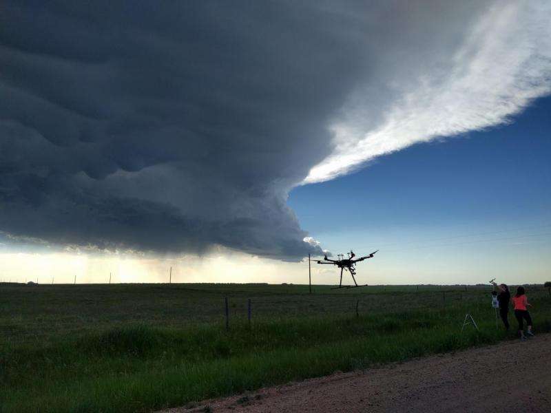
Video: High-flying, eye-popping drones gather data from storms

One evening in June, a thunderstorm loomed over Albin, Wyoming, just shy of the Nebraska border. Down a lonely dirt road, three vans full of Colorado State University atmospheric researchers shouted through walkie-talkies, guiding weather balloons and drones into a quickly darkening sky.
It was the CSU C3LOUD-Ex team, wrapping up its final day of a multiweek field campaign for storm observation and data collection. And Mother Nature saved the best for last. A textbook storm cell threatened, with several types of cloud striations and rain about 10 miles in the distance.
"This storm is really beautiful," said graduate student and C3LOUD-Ex project manager Leah Grant, just as the wind was picking up. "You can see rain here – and see these stripes in this region on the right? That suggests that [the storm] is rotating. That doesn't always happen."
C3LOUD-Ex, or CSU Convective Cloud Outflows and Updrafts Experiment, is led by Professor Susan van den Heever in the Department of Atmospheric Science. Supported by van den Heever's Monfort Professorship, the project's aim is to capture extremely hard-to-collect data from thunderstorms as they're happening. Specifically, the researchers are making direct observations of storm phenomena called updrafts and cold pools, employing a signature technology of unmanned aerial vehicles, or drones.
Updrafts are just what their name implies – a region of the fastest-rising air in the center of the storm. Cold pools are pockets of cold air that rush away from the raining region of the storm, along the surface of the Earth. Storm prediction models – crucial for early warning systems in tornadic areas, for example – do a poor job accounting for how updrafts and cold pools influence storms' formation, intensity and length. The C3LOUD-Ex scientists, including about 20 students from several research groups, are providing observational data around these processes. Their eventual goal is to improve predictive insights for severe weather.
"We don't do well simulating cold pools in our models," van den Heever said. "We don't know their structure, how intense they are, how cold and deep they get. We are making those measurements now to help us evaluate our models."
Monfort funds support thinking outside the box
If flying drones and balloons directly into storms sounds a little risky, consider that the Monfort Excellence Fund is reserved for just this type of outside-the-box, cutting-edge science.
Take the fact that the C3LOUD-Ex field campaign accomplished an unprecedented feat in storm observation, using a fleet of six DJI Matrice drones equipped with various sensors and camera. The drones measured cold pools and updraft air by flying in formation. For C3LOUD-Ex, CSU received a waiver from the Federal Aviation Administration to fly to a height of 350 meters in certain areas; typically drones are only allowed to climb to 120 meters.
Several times during the campaign, the researchers flew six drones in a stacked formation. As each drone hovered at a fixed location, they collected up to one hour of temperature, pressure and humidity information while the storm rolled over and around them.
"We were able to measure the whole structure of the cold pool," van den Heever said. "We could see that the cold pools were about 10 degrees cooler than their environment. No one else has ever measured the fine-scale structure of cold pools in this manner, using drones."
No 'I' in team
The teamwork involved in C3LOUD-Ex might rival the unprecedented nature of the experiments. Needing to get ahead of storms as they were forming, the campaign tracked daily weather minute by minute, employing the help of a forecasting and operations team at the CSU-CHILL radar in Greeley.
A sub-team was in charge of launching weather balloons the morning of each field day to get a read on the region's storm potential. Guided by their observations, the forecasting and operations team, and a little bit of luck, C3LOUD-Ex covered thousands of miles throughout northeastern Colorado, southern Wyoming and sometimes Nebraska. They raced ahead of storms so they could be in the right place at the right time.
With the field campaign wrapped up, van den Heever is now leading the analysis of the data. They're hoping for definitive insights into how updrafts and cold pools impact storm intensity, and the subsequent severe weather they produce.
Provided by Colorado State University


